Land Needs Assessment

Email [email protected]
City of Hamilton Revised Urban Land Needs Assessment (L.N.A.), 2031
A new report is now available by the consulting firm Watson & Associates that was prepared for the City in advance of an expected Ontario Land Tribunal (OLT) hearing regarding the 2009 and 2011 appeals to the City’s Urban Hamilton and Rural Hamilton Official Plans. The Report provides analysis on land needs to accommodate growth to 2031, based on the provisions of the former 2006 provincial Growth Plan. This report relates to the 2009 and 2011 appeals of the original GRIDS1 planning exercise and is not part of the GRIDS2 / MCR process which culminated in City Council’s 2022 adoption of the “no urban boundary expansion” growth scenario to the year 2051. However, it is being posted here for the public’s information.
Read the communications update
Land Needs Assessment to 2051
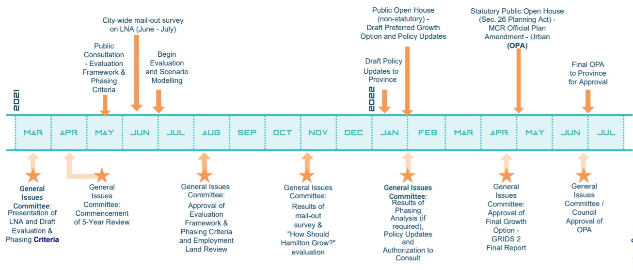
At the General Issues Committee meeting on March 29, 2021, Council tabled the staff recommendation for the Ambitious Density scenario. Rather, Council directed that additional public consultation be completed, by passing this direction: “That staff be directed to conduct a city-wide mail consultation with a survey on the Land Needs Assessment and the Municipal Comprehensive Review that includes the Ambitious Density Scenario, a “no boundary expansion” scenario, and that also allows residents to submit their own alternative scenario…”
Urban Growth Survey Results - A mail-out survey was distributed to households in Hamilton in late June/early July 2021 to ask for opinions about how the City of Hamilton should grow to the year 2051. The survey closed on July 23, 2021. For a summary of results of the Urban Growth Survey, and links for the associated staff report and appendices to be presented at the General Issues Committee on November 9, 2021, visit GRIDS 2/MCR Urban Growth Survey
What is a Land Needs Assessment?
A Land Needs Assessment (LNA) is a technical study that determines how much land is needed in the City of Hamilton to accommodate growth. The LNA must be completed based on a methodology developed by the Province and is a required part of the City’s Municipal Comprehensive Review process (MCR).
There are two categories of lands considered through an LNA:
- “Community” lands - areas for population, commercial and institutional growth
- “Employment” lands - areas specifically for employment growth like business parks and industrial lands
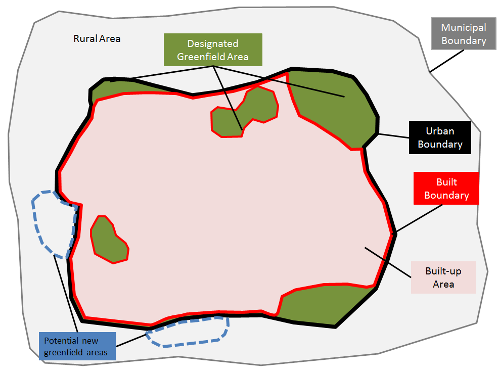
The LNA identifies how much of the forecasted population and job growth can be accommodated within the City’s existing urban boundary through infill/intensification in the ‘Built Up Area’ and existing Designated Greenfield Area lands. If there is more growth forecasted than can be accommodated in the City’s existing urban boundary, then the LNA determines how much urban expansion area may be required. Where this expansion might take place is not considered through the LNA.

Key Findings of Draft LNA
Community Area
An urban boundary expansion is needed to accommodate population growth to 2051.To accommodate new population growth, the City must plan for a higher percentage of residential intensification than the Growth Plan minimum target of 50%
Four residential intensification scenarios presented in the LNA:
- 'Current Trends' - 40% intensification, resulting in a required land need of 3,440 hectares.
- 'Growth Plan Minimum' - 50% intensification, resulting in a required land need of 2,200 hectares
- ‘Increased Targets’ - 50% to 2031, 55% to 2041, 60% to 2051 - resulting in a required land need of 1,670 hectares
- ‘Ambitious Density’ - 50% to 2031, 60% to 2041, 70% to 2051 - resulting in a required land need of 1,340 hectares
The ‘Increased Targets’ and ‘Ambitious Density’ intensification scenarios can be accommodated within the current Whitebelt land supply.
Employment Area
- Employment Land need and supply are anticipated to be balanced to the year 2051. No new employment land is needed.

