Cycling Routes & Maps
Hamilton Cycle Maps and Routes
Explore our interactive map and discover the city's best cycling paths. Whether you're planning a leisurely ride or an active commute, this page will help you navigate the city's cycling network with ease.
Find Bike Routes & Amenities in Hamilton
Search for bike parking and bike infrastructure by address. View map in new window
Hamilton Bike Map 2023 Edition
The Bike Map includes separated cycling infrastructure, Riding Safety information, the HSR Mountain Climber program and more! The next printed edition is being planned for 2026.
Discover Cycling Routes
Are you looking to discover great cycling routes in Hamilton for the first time – or discover areas of Hamilton that you are not familiar with?
Connection points
- Downtown: Corktown Park at Ferguson Ave./ Young St.
- East Mountain: Mountain Brow Blvd./ Limeridge Rd./ Arbour Rd.
Route design
- Easy: Paved trail, gradual slope
- Take care crossing Wentworth St.
City transit access
- Downtown: many HSR Routes
- East Mountain: Route 21, Route 22 nearby
- Bikes on Buses Program
Inter-city transit access
- Downtown: Hamilton GO Centre (GO Transit, Coach Canada, Greyhound)
Attractions along the way
- Downtown shops
- Bruce Trail
- Escarpment views
- Buttermilk Falls
- Albion Falls
Mapping
Connection points
- Downtown: Corktown Park at Ferguson Ave/Young St.
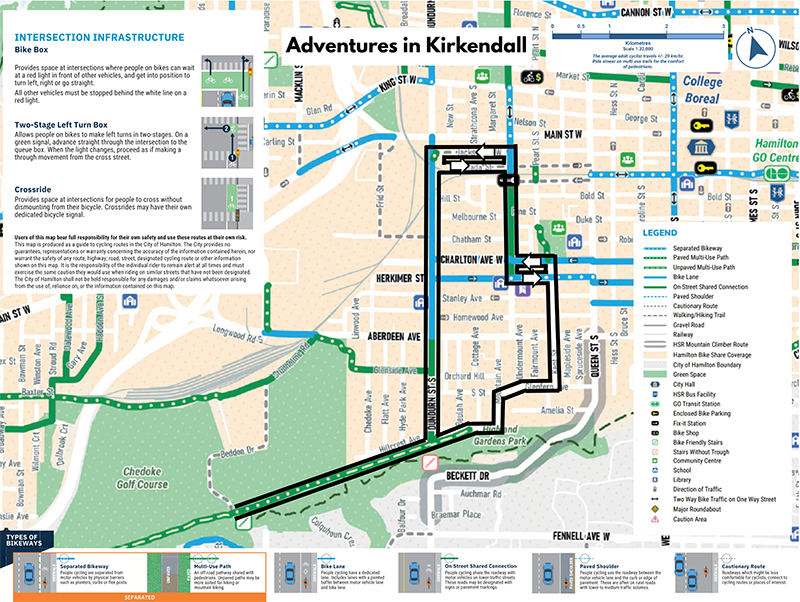
- Ancaster: Wilson St/Fiddler's Green Rd/Lovers Lane
Route design
- Easy: Combination of paved on-street and unpaved on Chedoke Rail Trail; stairs with trough crossing Highway 403. Northbound: no paved option west of Dundurn St.
- Take care on Charlton Ave. westbound or on Herkimer St. eastbound and at Wilson St.
City transit access
- Downtown: many HSR Routes
- Ancaster: Route 16, Route 5C/ 5A nearby
- Bikes on Buses Program
Inter-city transit access
- Downtown: Hamilton GO Centre (GO Transit, Coach Canada, Greyhound)
Attractions along the way
- Downtown shops
- Westcliffe Falls
- Princess Falls (five waterfalls total)
- Sanatorium Falls
- Iroquoia Heights Conservation Area
- Ancaster shops
Mapping
Connection points
- Downtown: Corktown Park at Ferguson Ave./ Young St.
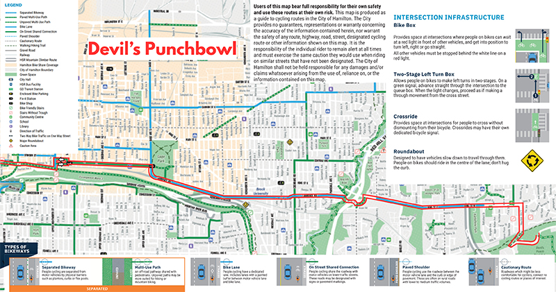
- Stoney Creek: Devil's Punch Bowl at Ridge Rd./ First Rd. E
Route design
- Moderate: All paved; mostly on-street (majority with bike lanes); walking trail up escarpment to Devil's Punch Bowl
- Take care crossing Wentworth St. and crossing Red Hill Valley Pkwy
City transit access
- Downtown: many HSR Routes
- Stoney Creek: Route 5, Route 58
- Bikes on Buses Program
Inter-city transit access
- Downtown: Hamilton GO Centre (GO Transit, Coach Canada, Greyhound)
Attractions along the way
- Downtown shops
- Gage Park
- Hamilton Children's Museum
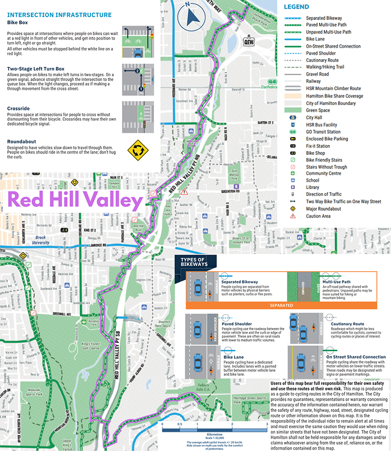
- Red Hill Valley
- Battlefield House
- Stoney Creek shops (including Stoney Creek Dairy)
- Devil's Punch Bowl
- Escarpment views over Lake Ontario
Mapping
Connection points
- Confederation Park: QEW/ Centennial Pkwy
- East Mountain: Mountain Brow Blvd./ Limeridge Rd./ Arbour Rd.
Route design
- Difficult: A few significant hills, Mostly unpaved - see map for paved on-street option
- Take care crossing Lawrence Rd. and along Mud St. beside Albion Falls
City transit access
- Confederation Park: Route 56 (seasonal), Route 11 nearby
- East Mountain: Route 21, Route 22 nearby
- Bikes on Buses Program
Inter-city transit access
- Confederation Park: Stoney Creek (Nash Rd.) GO Transit
Attractions along the way
- Confederation Park/ Wild Waterworks
- Steam & Technology Museum
- QEW Overpass Vista
- Red Hill Creek Valley
- EcoHouse
- Albion Falls
Mapping
Connection points
- Downtown: Corktown Park at Ferguson Ave./ Young St.
- Aldershot: Aldershot GO/ VIA Station at Waterdown Rd./ Highway 403
Route design
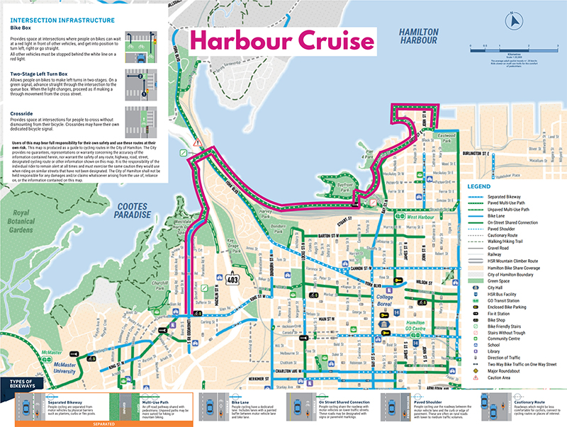
- Moderate: Combination of on-street and trails; all paved; stairs with trough at High Level Bridge connecting Desjardins Canal to York Blvd.
- Take care crossing Highway 403 ramps and on Plains Rd.; if travelling from Aldershot to Downtown do not cross York Blvd. at the High Level Bridge
City transit access
- Downtown: many HSR Routes
- Aldershot: Route 18, Burlington Transit 1
- Bikes on Buses Program
Inter-city transit access
- Downtown: Hamilton GO Centre (GO Transit, Coach Canada, Greyhound)
- Aldershot: Aldershot GO/ VIA Station
Attractions along the way
- Downtown shops
- Waterfront Trail
- HMCS Haida
- Bayfront Park
- Desjardins Canal & Fishway
- Cootes Paradise
- High Level Bridge Vistas
- Royal Botanical Gardens (RGB)
Mapping
Connection points
- Aldershot: Aldershot GO/ VIA Station at Waterdown Rd./ Highway 403
- Confederation Park: QEW/ Centennial Pkwy
Route design
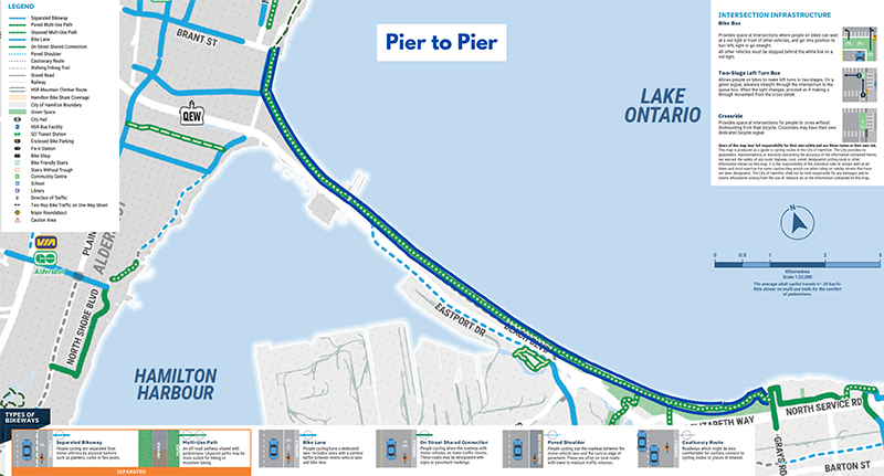
- Easy: Paved; half of the route is paved trail (Waterfront Trail) or optional on-street (Beach Blvd.)
- Take care crossing under the QEW on North Shore Blvd. and crossing the lift bridge
City transit access
- Aldershot: Route 18, Burlington Transit 1
- Confederation Park: Route 56 (seasonal), Route 11 nearby
- Bikes on Buses Program
Inter-city transit access
- Aldershot: GO/ VIA Station
- Confederation Park: Stoney Creek (Nash Rd.) GO Transit
Attractions along the way
- Burlington waterfront shops
- Lift Bridge/ Canal & Lighthouse
- Lake Ontario beaches & restaurants
- Confederation Park/ Wild Waterworks
Mapping
Connection points
- Ancaster: Wilson St./ Fiddler's Green Rd./ Lovers Lane
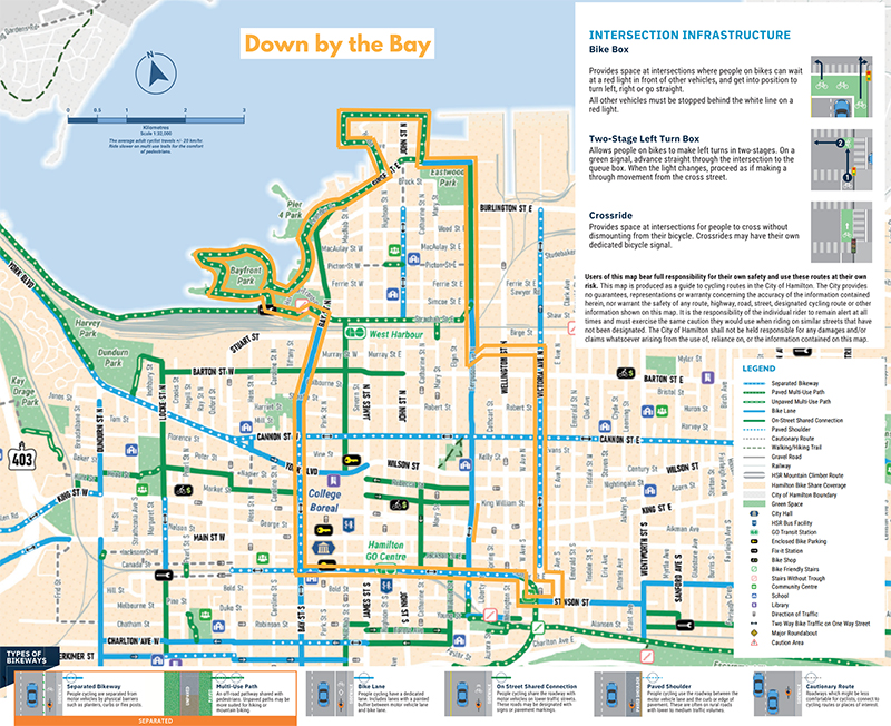
- Hamilton Harbour: Bayfront Park, Bay St./ Barton St.
Route design
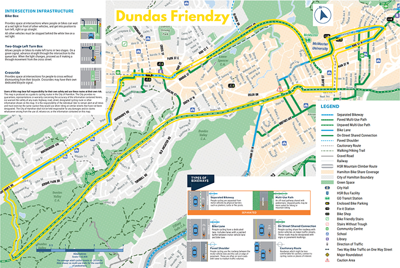
- Easy: Combination of on-street and trails; unpaved on Rail Trail in Dundas Valley; paved option between Ancaster and Dundas is Wilson St./ Old Dundas Rd
- Take care on Sulfur Springs Rd. and on Dundas streets
City transit access
- Ancaster: Route 16, Route 5C/ 5A nearby
- Hamilton Harbour: Route 99 (seasonal), Route 4, Route 2 nearby
- Bikes on Buses Program
Inter-city transit access
- Downtown: Hamilton GO Centre (GO Transit, Coach Canada, Greyhound)
- Westdale: McMaster University GO Transit
Attractions along the way
- Ancaster shops
- The Hermitage
- Griffin House
- Dundas Valley Trail Centre
- Dundas shops
- McMaster University
- The Aviary in Churchill Park
- Westdale shops
- Cootes Paradise
- Desjardins Canal & Fishway
- Dundurn Castle
- Waterfront Trail
- Bayfront Park
Mapping
Connection points
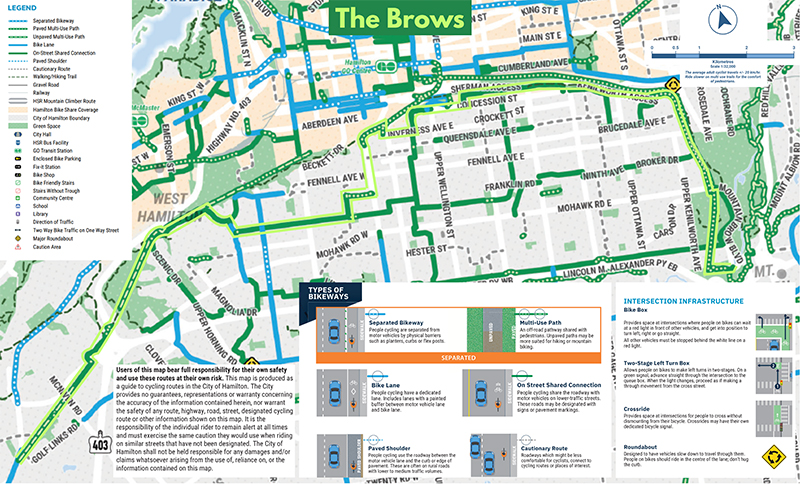
- East Mountain: Mountain Brow Blvd./ Limeridge Rd./ Arbour Rd.
- Ancaster: Wilson St./ Fiddler's Green Rd./ Lovers Lane
Route design
- Moderate: On-street shared with motor traffic; Mostly paved - unpaved on Chedoke Radial Rail Trail; stairs with trough crossing Highway 403; NB: no paved option west of Scenic Dr.
- Take care of traffic along Concession St.
City transit access
- East Mountain: Route 21, Route 22 nearby
- Ancaster: Route 16, Route 5C/ 5A nearby
- Bikes on Buses Program
Inter-city transit access
- None
Attractions along the way
- Albion Falls
- views from the brow
- Concession St. shops
- Sanatorium Falls
- Iroquoia Heights
- Ancaster shops
Mapping
Connection points
- Ancaster: Wilson St./ Fiddler's Green Rd./ Lovers Lane
- Aldershot: Aldershot GO/ VIA Station at Waterdown Rd./ Highway 403
Route design
- Moderate: Paved on-road, but for 500m of gravel on Binkley Rd.; two escarpment climbs
- Take care riding up the escarpment: As you scale the escarpment, don't get intimidated, just do it "smooth and slow". Use low gears, a slow pace and patience. A bike with a triple chain-ring in front makes it quite easy for most people. Going down? Be sure to maintain control at all times.
City transit access
- Ancaster: Route 16, Route 5C/ 5A nearby
- Aldershot: Route 18, Burlington Transit 1
- Bikes on Buses Program
Inter-city transit access
- Aldershot: GO/ VIA Station
Attractions along the way
- Ancaster shops
- The Hermitage
- Griffin House
- Crook's Hollow
- Tew's Falls
- Webster's Falls
- Borer's Falls
- Waterdown shops
- Great Falls
Mapping
Connection points
- East Mountain: Mountain Brow Blvd./ Limeridge Rd./ Arbour Rd.
- Ancaster: Wilson St./ Fiddler's Green Rd./ Lovers Lane
Route design
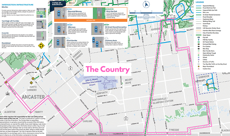
- Easy: Paved on-road and a short paved trail section by Albion Falls over the LINC.
- Take care crossing Rymal Rd., crossing Highway 6/ Upper James, Wilson St. at roundabout, and along Jerseyville Rd.
City transit access
- East Mountain: Route 21, Route 22 nearby
- Ancaster: Route 16, Route 5C/ 5A nearby
- Bikes on Buses Program
Inter-city transit access
- None
Attractions along the way
- Albion Falls
- Red Hill Valley
- Eramosa Karst
- Lake Niapenco
- Ancaster shops
Mapping