Official Plan
Major Transit Station Areas

Join our Notification List
Do you want to be notified of:
- Updates respecting the Official Plan Amendments for Major Transit Station Areas.
- Meetings (e.g. Open Houses, Statutory Public Meetings) respecting Major Transit Station Areas
Contact Us
Jennifer Allen
Planner I
City Hall, 4th Floor
71 Main St W, Hamilton
Call: 905-546-2424 ext. 4672
Email: [email protected]
What are Major Transit Station Areas?
The areas surrounding existing and planned higher order transit corridors are a major focus of future growth, intensification and redevelopment in the Province of Ontario. Higher population and employment densities are planned within these areas to support transit. Increased densities and a mix of uses along transit corridors contribute to a complete community with easy access to housing, jobs and local amenities.
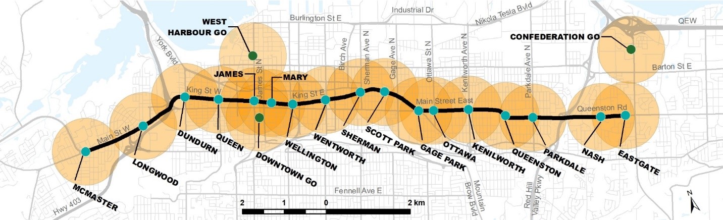
Major Transit Station Areas (MTSAs) are generally defined as the area within a 500 to 800 metre radius of a higher order transit station representing about a 10-minute walk. The City of Hamilton is currently planning for MTSAs in the lower city, including seventeen (17) LRT stations and three (3) GO stations which are identified on Appendix B – Major Transportation Facilities and Routes to the Urban Hamilton Official Plan.
The Provincial Planning Statement has established minimum density targets for MTSAs. In Hamilton, these densities are 160 people and jobs per hectare (pjh) for areas serviced by the LRT and 150 people and jobs per hectare for areas serviced by the GO transit rail network.
Urban Hamilton Official Plan
An interim policy framework for Major Transit Station Areas was added to the Urban Hamilton Official Plan through Official Plan Amendment No. 167 which was approved by the Province on November 4, 2022. The policies direct that the City will delineate the boundaries of the Major Transit Station Areas and update the policy framework through a future Amendment to the Urban Hamilton Official Plan.
The City has completed the detailed review of the Major Transit Station Areas to demonstrate the City’s existing land use permissions allow for sufficient intensification to meet the Provincial Planning Statement minimum density targets (160 pjh and 150 pjh).
The draft results of this review were presented to Planning Committee on September 19, 2023 through Report PED23105 which identified the boundaries of each Major Transit Station Area as well as the areas of intensification used to model the development / redevelopment potential and estimate the density in people and jobs per hectare.
The findings of the Major Transit Station Areas Report Addendum (February 2026) prepared by Dillon Consulting demonstrate the in-effect land use permissions within the City’s Major Transit Station Areas allow for sufficient intensification to meet the minimum density targets prescribed by the Province. The final results and proposed Official Plan Amendments will be presented to Planning Committee on March 24, 2026 through Report PED23105(a).
Protected Major Transit Station Areas
A Protected Major Transit Station Area is a sub-set of Major Transit Station Areas where Inclusionary Zoning (IZ) may be applied. The City is recommending all Major Transit Station Areas be identified as Protected Major Transit Station Areas, subject to the Minister of Municipal Affairs and Housing approval. The Urban Hamilton Official Plan must include policies to specify permitted uses, identify minimum residents and jobs per hectare, and identify minimum densities within Protected Major Transit Station Areas.
View more information on Inclusionary Zoning.
Learn More About Major Transit Station Areas
Date modified