Environmental Assessments
Westdale Neighbourhood Neighbourhood Traffic Management Study

Contact Us
Bryan Purins, Project Manager
Roadway Safety
Call 905-546-2424 ext. 1713
Email [email protected]
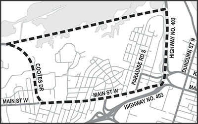
The City of Hamilton has completed the Westdale Neighbourhood Traffic Management Study to identify and recommend potential transportation-related improvements for the neighbourhood. When implemented, these improvements will benefit all road-users and better reflect the Complete-Livable-Better Streets concept of design outlined in the 2018 Hamilton Transportation Master Plan.
Location: Westdale Neighbourhood, Ancaster
Study Status: Completed (2020)
Classification: Schedule B
Project File Report
Westdale Traffic Management Study Final Report Appendix A - Public and Agency Consultation Appendix B - Public Information Summary #1 Report Appendix C - Public Information Summary #2 Report Appendix D - Planning Context Report Appendix E - Evaluation of Alternatives Memo Appendix F - Existing Conditions Report Appendix G - Future Conditions Report
Date modified